
Sebago to the Sea: All the portages, put-in’s and take outs!
On 5/22/2024 I decided to try to paddle the entire Sebago to the Sea Water Trail: the weather was 83 degrees; the water level in the river was dropping quickly with no rain. It was my best window to have enough water to do ALL the segments on the PRLT water Trail Map: from the route 35 bridge, to Martin Point (sometimes called Martin's Point or Martins Point) in Casco Bay down in Portland, 25 water miles away, and 19,068 feet of dry-land portages!
(P.S. The Mountain Division Trail is a truly wonderful thing: it is a hiking trail 25 miles from Sebago to the Sea, and it has some unreal, unbelievable sights... but that's for another day...)
https://www.prlt.org/water-trail
But first things first, Wednesday is going to be a very unusual 83° day here in Southern Maine. It has not rained in sometime and the water levels have all been dropping. I think the most important thing about undergoing 25 mile trip with many portages and on some new segments of river and Bay, is first and foremost be safe about everything. Check the wind and the tide conditions carefully. Bring plenty of water. I brought a gallon jug of water and a 12 pack of Pepsi. I also brought a Tupperware full of sandwiches. And most definitely have your phone well charged and have at least one Ziploc bag to keep it dry. It’s a huge help being able to see the PLT map, but especially to see the Google map to get you from one street to another or through the woods or to a parking area. I can’t emphasize how important the phone turned out to be in this adventure, especially when mine ran out of batteries, and I got lost on the city streets of Westbrook! Saying this I’m fully aware that almost everywhere on the river is easy access to the shore and to roads and to people and many places there are stores nearby, and of course you could always call for a lifeline, especially if you have very sweet wife and sweet kids if you get in a pinch. It’s also very important to study the different pages before hand, study the traffic on the streets, and of course, study the river for hazards. The river is constantly changing: I encountered several sporadic little rapids here and there in the middle of the river, which probably only appear at certain river Heights. Today these were all no more than class one riffles and sniffles. There are several named and well-known rapids such as the 6 dam falls, and Presumpscot Falls.
You’ve probably seen those small “sebago to the sea” signs hidden here and there all over southern maine: excellent hiking trail they say, but I'm here for the paddling. So this spring, I knew I had to make a canoe trip from Sebago Lake 25 miles down to Casco Bay. It was a great trip. I highly recommend it, and here’s everything I learned:
The story of the Presumpscot is very much the story America: home to Wabanaki people for thousands of years, the name Presumpscot is said to mean river of many Falls or river of many rough places. And when the first colonizers from Europe came to the area written History records it being the most fish the colonizers had ever seen. But from the 1660s on, industrial development occurred first with sawmills and papermills, canals were built, and many dams. This completely stopped fish flow to the Wabanaki people upstream: battles and wars ensued, driving the Wabanaki people out of the area. In the 21st century, restoration programs, including fish ladders, dam removal, River trails and River preserves have begun restoring the Presumpscot to its former beauty. migratory fish are returning, & people have been returning to the river in every season.
So I’ll be following the PRLT‘s Presumpscot water Trail paddle map from its beginning at the source of the Presumpscot where it passes under the route 35 bridge after the eel weir dam, & taking out at Martin’s point in Casco Bay in Portland. The basic format for the video will be to first show the PRLT's water Trail map and it’s put in takeouts and portages, second to show a Google map, third to show video scouting from the shore when I have it, and fourth, actual footage from the trip when I have that.
I’ll have to spend a little extra time explaining the first segment because of all the confusing names, crossovers, canals, and connections.
As you’ll see from the PRLT map, it says "route 35/eel weir: note this paddle section is not recommended". It also says plan to bushwhack portage around the eel weir Falls if putting in here. More on that later, but those falls are no problem at all to portage.
An easy way to scout the dam and get a good understanding of how the water flows between the lake, the basin, the power canal and the Presumpscot, is to hike upstream from the canal on route 35 and just to the right side of that there is a small Grass trail through the woods which leads straight to the eel weir dam.
A wonderful Sebago historian named Roger Wheeler has helped me understand this confusing geography: The headgate dam was originally called the basin dam and it was finished around 1830. in 1904 the canal was built and water was almost completely completely diverted from the presumpscot river to the canal. The dam was then renamed the eel weir dam & the canal became the "power canal". The powerhouse for Hydro-Electricity was built a mile and a half downstream at the terminus of the power canal.
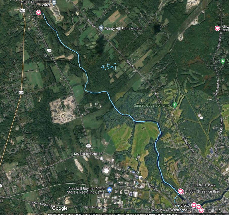
Hawks preserve to Little Falls dam. Now this next section is one where I differ significantly from the PRLT map and recommendations. PLT calls this a car portage they incorrectly. Say the length of the portage is 0.5 miles in fact it is 1 mile exactly on the map the little Falls down portage is listed as “difficult drive on Roads walk trail haul out at the hawks, preserve wooden steps and then load up car at the trailhead Drive south either Madison Street or Canal Street parking and launch site”. I was not interested in doing any car portages but the route they mark down the tow path Road and then onto busy route 202 around a traffic Circle down mosher Road and Mallison Street and then Canal Street would be difficult and dangerous for both boat and for the traffic. Instead, I decided to just bend one little rule a little bit.
I find no suitable spot along either sure before the route 202 Gray Rd. bridge over the pres Scott. The right to Stephen Rocky. The left goes right up to the red city ale house and is also steep with a bad surface and the parking lot is always full of cars with no way to pull a boat between them. There is extensive construction right now on route 202 with single lane traffic cars, unpleasantly waiting to drive past with heavy equipment all over that section of the road. I think it was much safer to go under the bridge. A very short distance and take out River left right after the bridge. I know there are a big sign saying do not proceed forward. Do not go into this bridge danger dam. But right under the bridge there is an official City marked fishing area with a parking lot for fishing also, so I think it’s perfectly safe to go onto the bridge under the lines. Just take out right at the fishing spot a few feet downstream. From there, it’s easy to pull the boat across a lawn at the apartment building with a very gentle slope up to depot Street and from Depot Street it’s just 500 street 500 feet uphill to the very easy off-road portage called the mountain division Trail, which is also a PRL. Strangely, they don’t mention this at all for a portage, but it’s a very easy flat slightly downhill portage all the way down to Mallon and beyond.
At Madison Falls it’s true. There is a very nice portage on Canal Street with parking stairs and even a canoe slide, but again I found it easier to just take the mountain division Trail all the way down to Madison Falls and then to River left and into the woods for a short distance and put directly across from the canal Street boat ramp there are a few small class one rapids here And I thought this was a lot safer and easier and more in the spirit of the trip than doing a car portage.
Cumberland Mill Dam portage downtown Westbrook: again PRT implies that there is no portage here that there is no way to paddle this segment from below the Cumberland Mills damn, that you can paddle up from the 302 trailhead but you can’t put in below the sappy plant. That’s not really accurate: and everybody knows that by law the damn owner is supposed to provide ready and easily doable. Portage around their damn. The dirty little secret is they almost certainly do not have any portage below the mail, and I kind of get that: Right behind the mail here are for giant waste water treatment tanks. This is the exact area where a giant landslide occurred just a few years ago which completely blocked the river. I wasn’t gonna push it. It was pretty easy to find an alternate portage through a nice grass trail. Portland Trail Has excellent networks of trails that lead almost up to the spot. The presents Scott river Trail seems to stop a little bit after the city of Portland shelter and homeless facilities. I didn’t explore the trail all the way down that far but it certainly looks like a trail from Tri-City welding following River right
Memorial to Abenaki leader killed in 1756 unveiled in Westbrook
Chief Polin, who championed saving the Presumpscot River, had walked to Boston to make his case.
Posted
September 30, 2018
Updated
September 30, 2018
 Eric RussellPress Herald
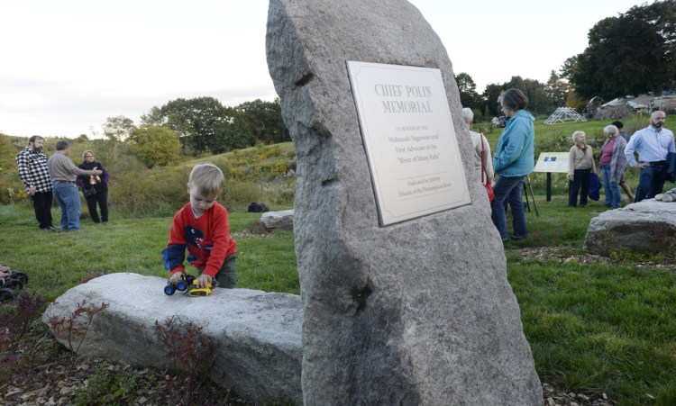
Aebel Shaughnessy, 3, of Westbrook plays at the memorial garden honoring Chief Polin and the First People of the Presumpscot River before its dedication Saturday in Westbrook. Staff photo by Shawn Patrick Ouellette
WESTBROOK — For centuries, indigenous people lived undisturbed in the area between Sebago Lake and Casco Bay, their livelihood tied to the Presumpscot River and its bounty of salmon, bass, trout and other sea-run fish.
When Col. Thomas Westbrook, who later had a city named after him, and other European settlers built dams on the river in the 1730s to help power paper mills and gristmills, the fish stopped running. The major food source of the Abenaki people was threatened.
The tribal leader, Chief Polin, didn’t surrender quietly. He twice walked to Boston – Maine was still part of the Massachusetts Bay Colony then – to persuade the Colonial governor, Jonathan Belcher, to intervene and order the mill owners to install a fish passage. Belcher said he would but it never happened. Polin eventually armed his people to fight for access to something that had been theirs for generations.
He was killed in 1756 in what is now the town of Windham by Stephen Manchester, an early settler who is still recognized as a hero for ending what had been a drawn-out conflict. Not long after Polin’s death, his people either retreated or went into hiding.
The Presumpscot, which means river of “many falls,” still runs through the area today, yet there is nothing that signifies Chief Polin’s place in its history.
Michael Shaughnessy and others with the nonprofit Friends of the Presumpscot River wanted to change that.
Advertisement
On Saturday, before a crowd of about 75 people, Shaughnessy unveiled a memorial to Polin – a massive stone marker with a plaque bearing his name, along with four additional granite slabs to signify the four native tribes still active in Maine and a set of informational boards that detail Polin’s and the river’s history. The monument sits on the back edge of Shaughnessy’s property on Conant Street, not far from the Presumpscot River where Polin and his people used to fish and where they planted corn, beans and squash near its fertile banks.
It will be accessible to the public from the Conant Trail, a part of the Portland Trails system near Saccarappa Falls that connects to Main Street in Westbrook.
Shaughnessy said it was “stunning” that Polin had not been recognized publicly in more than 250 years.
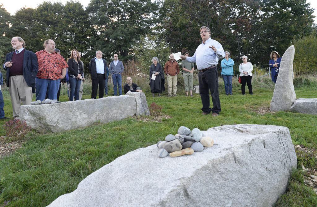
Michael Shaughnessy, president of Friends of the Presumpscot River, speaks during the dedication of the memorial garden Saturday.
“This is a living memorial. It’s going to change and grow with time,” he said, encouraging those in attendance to pick up small stones that were gathered and set them at the base of the monument to mark that they were there.
Westbrook Mayor Mike Sanphy, who also serves on the local historical society, said Polin is a great part of the city’s history, but sadly one that has been “lost to obscurity.” He praised the efforts of Shaughnessy and others who made the memorial a reality.
Indigenous people have long been underrepresented in history books, although that is changing. Shaughnessy said much of what has been learned about Polin has come from research by Lisa Brooks, a Native American historian and professor at Amherst College who attended the memorial unveiling and was recognized for her efforts.
“She gave our mission a depth we never could find,” Shaughnessy said.
Brooks said she was always struck by what Polin said to the Colonial governor after he traveled by foot to Boston to make his case for saving the river. He said the Presumpscot “is the river which I belong to.”
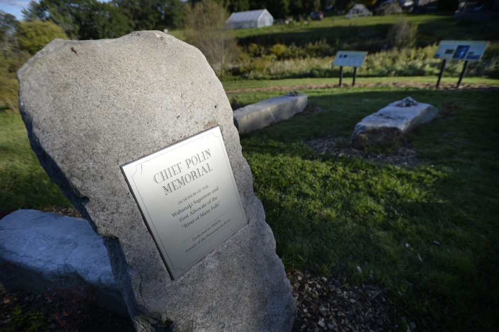
The memorial garden to Chief Polin on a section of Portland Trails at The Farm at Conant Homestead in Westbrook on Saturday.
“That phrase really meant a lot,” Brooks said. “If we unpack that a little, we see how they really understood their kinship to this place – their incredible dependence on this river and this land.”
The river is still being fought over. The Friends of the Presumpscot River have been working since 1992 to improve water quality and, eventually, to remove dams and restore native fish to the waterway.
List of all the Portages, put-in's and Take-out's:
Follow along on the PRLT Water Trail Map PRLT Water Trail Map
1. START: Eel Weir Dam: Presumpscot side
Hike across rt 35 from the parking area, about 500 ft into the woods, put in is gentle slope, paddle under the bridge

2. Eel Weir Falls: If you start on the Presumpscot side, after about 1 mile, you will see the Eel Weir Power House discharge and the Eel Weir Falls just below the power house. Take out here, river left, gentle slope up to scenic observation area for the falls and the power house. Carry boat about 300 ft to a gentle slope after the falls, put in in swift water down to North Gorham Dam
1A. Alternate start: Eel Weir Power Canal:
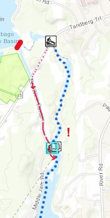
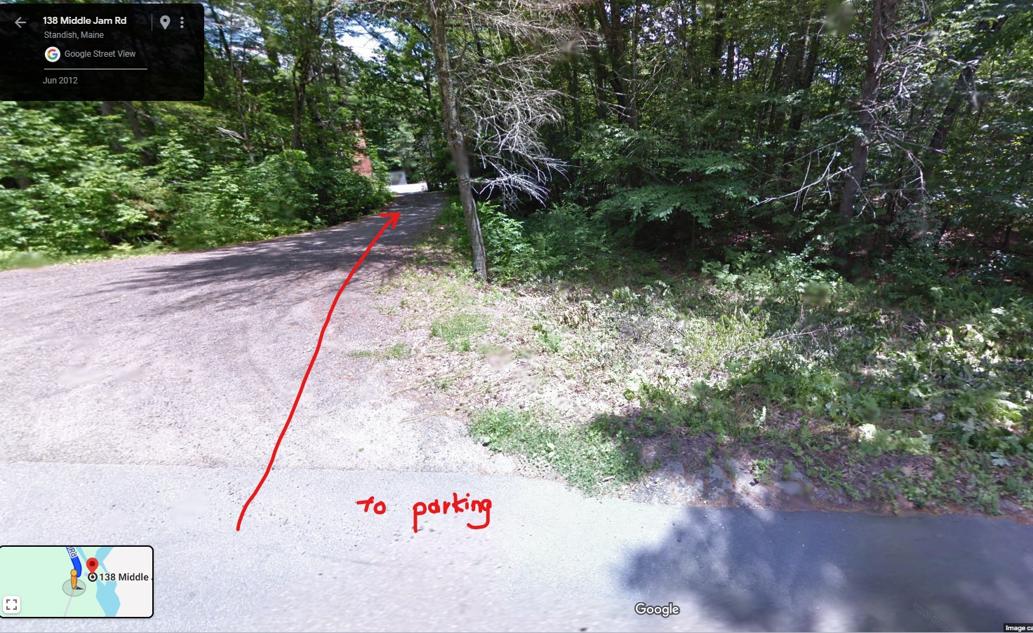
If you must paddle the Power Canal, PROMISE you won’t go anywhere near the hydroelectric powerhouse turbine input!!! There are 2 parking spaces shortly after the corner of rt 35 and Middle Jam Rd. Climb up the canal hill. Be alert and take out WAAYYY before the signs say “DANGER DO NOT PASS THIS POINT” There are several easy pathway openings to Middle Jam Rd; carry boats about 900 ft down rd to Eel Weir HydroElectric Project parking lot, then follow the water trail till you find a doable place to put in (sort of steep hill slope) to easy swift water from the powerhouse.
1B. Alternate Alternate Start: Eel Weir Project parking lot: Some people start their trip here at the EWHP parking lot around 138 Middle Jam Rd: park here, then find a safe place to climb down the hill to the easy swift water right after the power house (sort of steep slope) which joins with the Presumpscot.
3. North Gorham Dam:
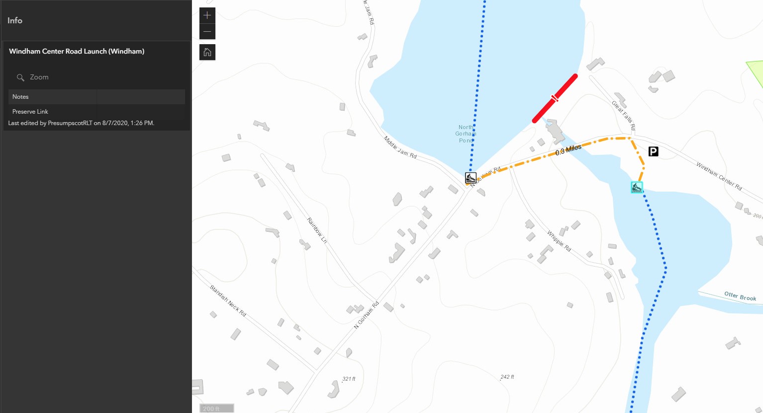
Take out river right, along Middle Jam Rd. The shore is very shallow and easy to pull a boat up the short slope. Carry along Windham Center rd (fair amount of traffic, heads up!) to North Gorham Station Recreation Area (5 Windham Center Rd, Windham) nice river spot, easy put in.
4. Dundee Dam
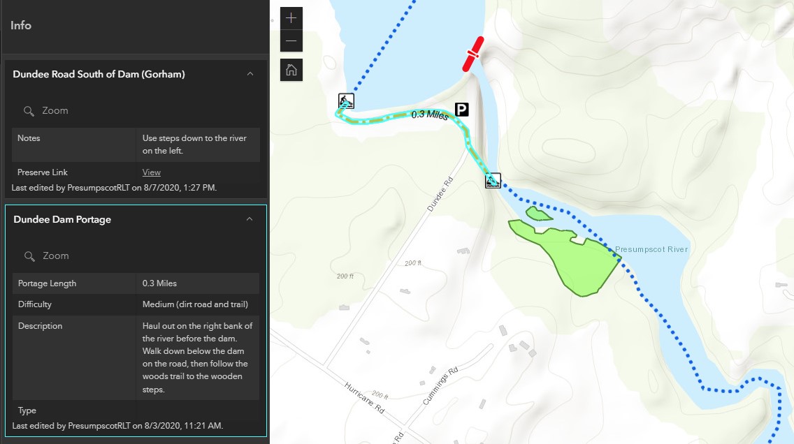
Take out on the right, at the edge of the woods and a concrete wall, down the dirt road to Dundee Rd, into the wooded trail to Cummings Preserve Trailhead, down the wooden stairs to the water, easy put in (about 1700 ft total)
5. Gambo Dam
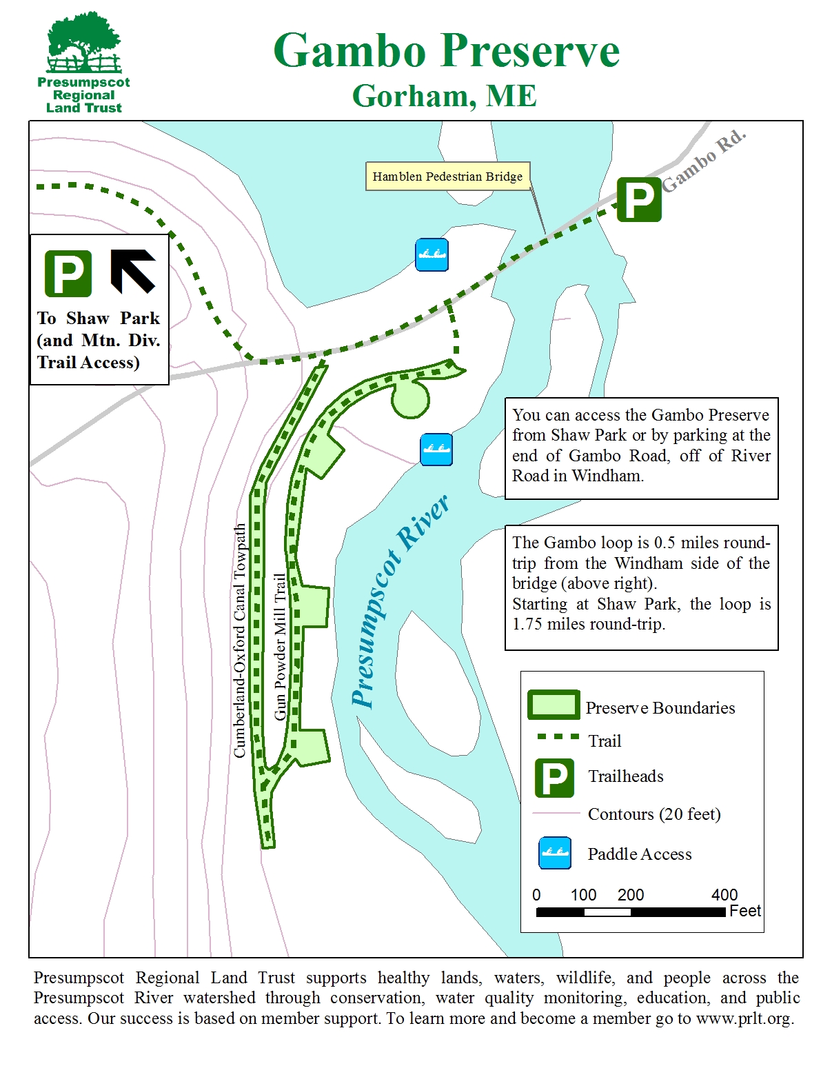
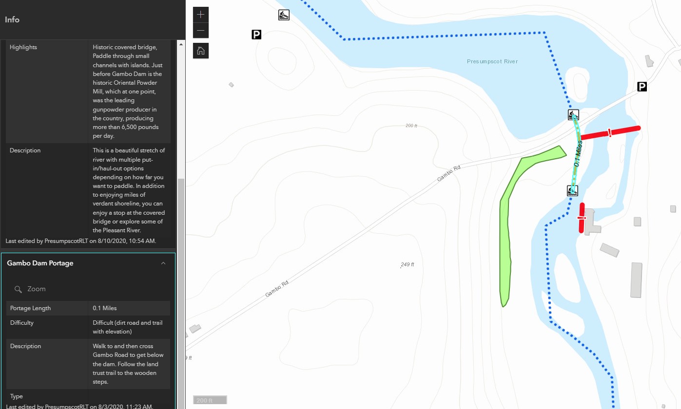
Again, PRLT says to take out right next to the dam on the hill on the small peninsula: maybe that’s fine for most people: i’m slow, have a heavy boat, etc so I took a flat easy well worn dirt path off to the right that comes out on the Gambo Preserve Trails. Follow those trails about 500 feet along the river (several ways to get down to the river). Supposedly there are wooden steps to the water somewhere, I didn’t see them, but the dirt hills are very easy to climb down to the water. Put in on quickwater (maybe tiny rapids).
6. Little Falls Dam
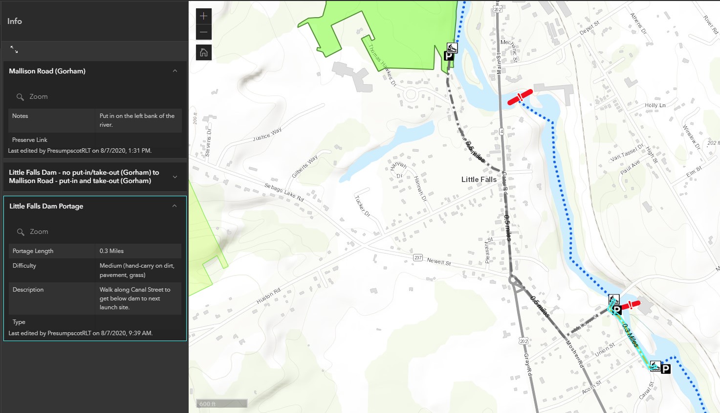
Me and PRLT agree: just portage this 0.4 mile portion of the Presumpscot between Little Falls and Mallison Falls. There is NO good put-in access anywhere from Little Falls Dam all the way till Mallison Falls (you can only put in At Mallison Falls and paddle the segment upstream). Me and PRLT disagree on how to portage this stretch:
6.1 PRLT Car Portage: Take out at Hawkes Preserve Parking, load your boat on your car, and drive dwon the Towpath, then rt 202, then Mosher Rd to Mallison St, then park your car at one of the 2 Canal St parking areas (drive 0.8 miles, or 0.5 miles). Put in at 51 Canal St Parking lot, carry down wooden stairs and boat chute, put in in tiny riffles.
6.2 Mountain Division Trail Portage hiking Portage: My own personal route, danger, use at your own risk!
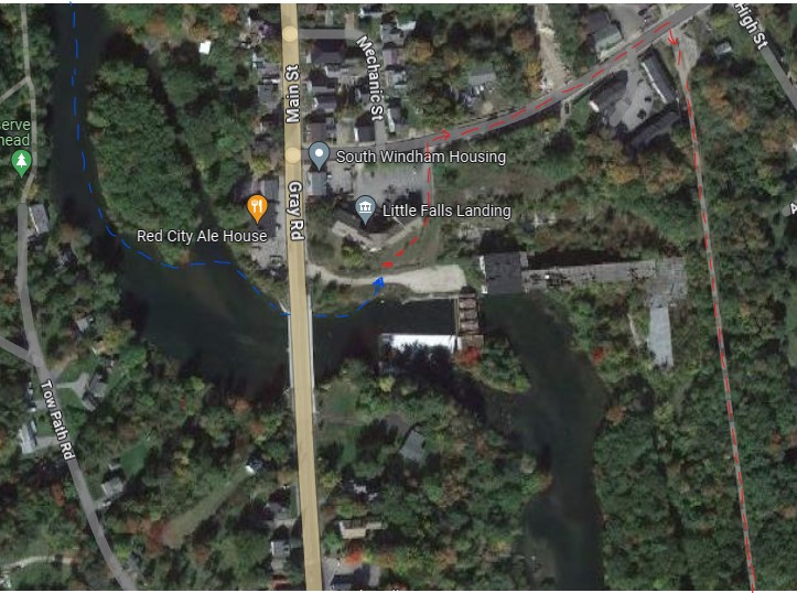
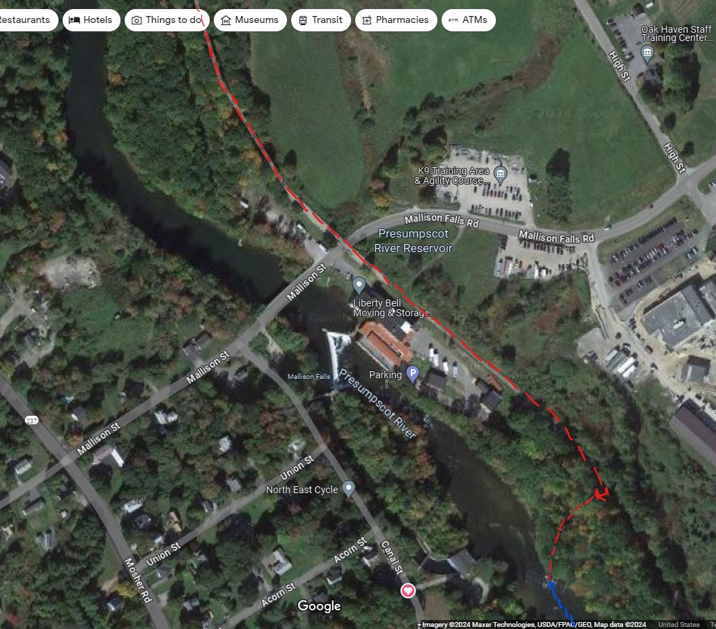
Paddle all the way to the rt 202 bridge down river left, past the sign that says “DANGER DANGER Do not proceed beyond this point”. Duck under the floats, go under the bridge, take out JUST AFTER THE BRIDGE!!! At the City’s Fishing Access spot. Go up the parking lots and grass hill to Depot St. Go up Depot St for 900 ft, then turn right down the Mountain Division Trail. Then hike down Mountain Division Trail for 4050 ft, past Mallison Falls, then climb down the hill to the river put-in across the river from the Canal St put-in/Mallison Falls Hydroelectric Project at 51 Canal St. into swiftwater, tiny riffles and skiffles.
(N.B. Obviously, no one should recommend ignoring a Danger Sign, but it is just a few feet further, and you avoid busy rt 202 traffic and a somewhat difficult portage into the busy Red City Ale House parking lot. The alternative hiking portage is to try taking out before the bridge, onto Red City Ale House land or onto a private home, or possibly taking out river right just before the bridge, and dragging up the hill through brush.)
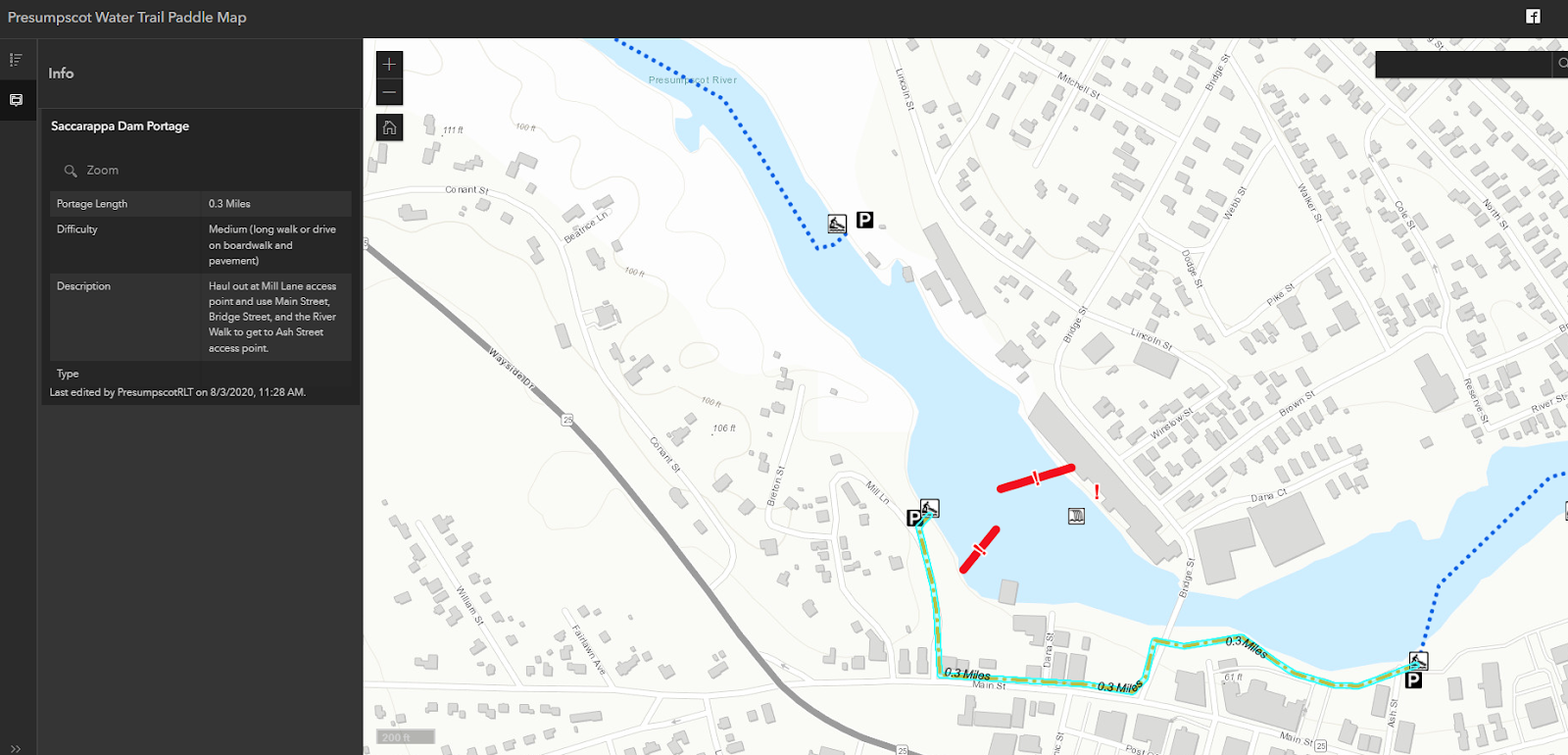
7. Saccarappa Falls
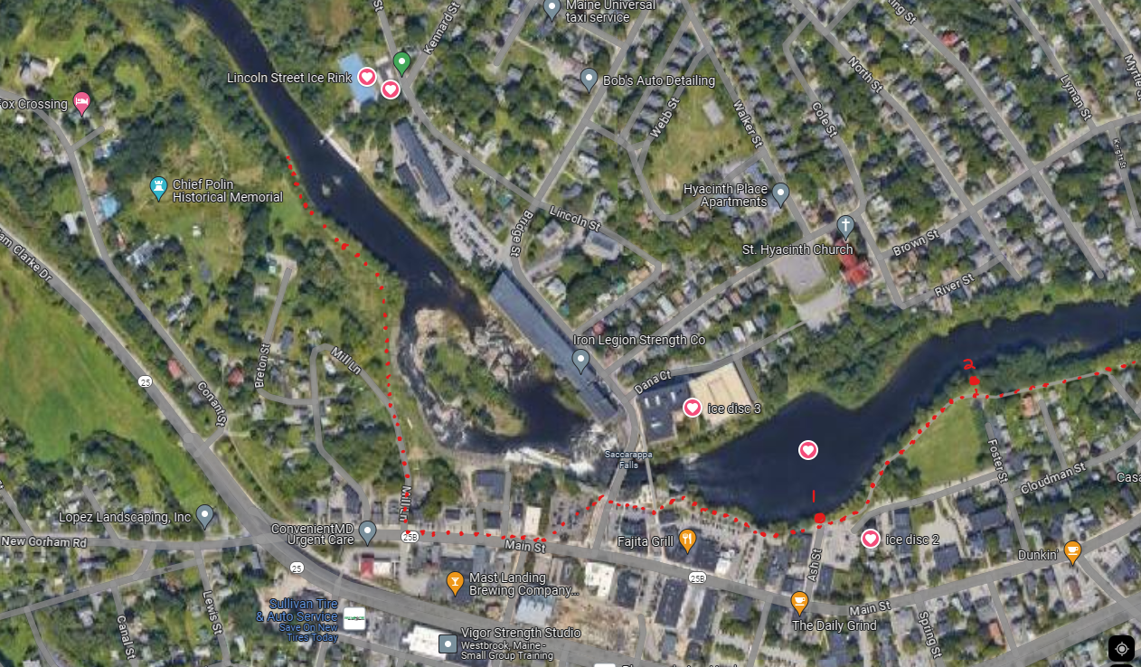
Take out river right just across from the river from the Lincoln St Hockey Rink; easy slope, follow flat grass path 1000 ft to Mill Ln. From Mill Ln, Turn left onto Main St (busy city traffic, but good sidewalks and walkways and riverwalk trails). Cross Bridge St, follow Westbrook Riverwalk trail to put in near Ash St, Foster St, or Riverbank Park. (the city usually puts up boat docks at several locations, but if there are none, put in the river at the easiest flattest safest spot. Ash St was OK, Riverbank looked the best.)
(P.S. I’ll just mention the PRLT trail recommendation seems dangerous here: they say to take out right at Mill Ln, but those are often strong rapids with powerful fast current and a rough rock-pile shore: take out way before this spot!) Don’t take out there…
8.
No comments:
Post a Comment